Friday, June 13, 2014

A Ride Around the Block in South Dakota, Iowa and Nebraska


While fleeing from Decatur to Yankton, we passed a lot of area we had intended to check out if we'd had a normal driving day, and probably would have spent a night or two along the way doing that before getting to Yankton. So, we did a ride around the block to make up for it on Saturday, June 7th.

We left the campground around 9 o'clock and headed over the bridge to Yankton to pick up Rt 50 east. We drove out Rt 50 to CR-454 and drove 
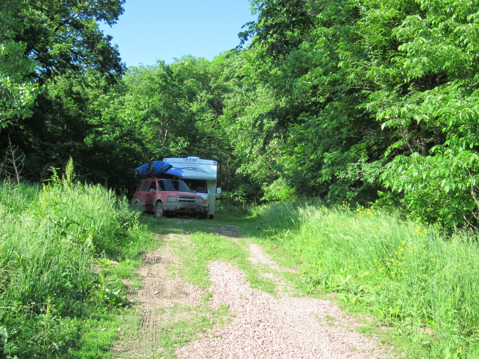
south on it 7 miles to the river. We wanted to check out a takeout point on the Missouri, Myron Grove Landing, for a paddle we're planning for Wednesday the 11th, from the campground to there, about 22 miles. We'll run the car down the afternoon before, come back to the campground with the camper for the night and leave early the next morning. Some pics at the take out point:


From there we back tracked about a mile, then continued east on back roads to Vermillion. After finding some lunch-to-go, we drove up Rt 19 north to Spirit Mound, which is a pointy rise in the land that Lewis & Clark saw from the river, 9 miles away. The local natives told them that the place was inhabited by “little people” (or “Deavels”, “about 18 inches tall with large heads”, as L & C's describe them in their journal), who shot anyone with arrows if they trespassed on the sacred mound. L & C took 11 men and Seaman (Lewis's dog) and hiked the 9 miles northeast to the mound. It was a tough enough hike that they had to send Seaman back to the boat, being late August, very hot, and Seaman being a big, shaggy Newfoundland. The boat was being watched by 2 more troops of the expedition. They saw a lot of firsts from the top of the mound. Since this was their first trip away from the river since they'd entered the plains, they took in a view of the surrounding prairie, hundreds of buffalo, some badger or coyote dens, numerous species of birds, and found a lot of various kinds of ripe fruit back down on the plains around the mound.

They were thirsty when they left, so they made a 3 mile detour northeast to the Vermillion River, and followed it back to the Missouri, and back to their boat. A mere 25 miles as the crow flies, and half of that river miles, which can be a WAY longer and more difficult path, all in one day! I've said it to K many times since the St. Louis museum-they had to have been some very, very tough men and woman.

We, on the other hand, got there in 15 minutes-it was an exhausting drive! Had lunch and grabbed the girls and hiked the mile up to the top. It was a cool, cloudy day. We met a couple of women at the start, one of whom was a local South Dakotan. She gave us a bunch of tips on what to see and where to go on the rest of our drive north through South Dakota, when we told her what we were doing. A fun conversation with them. Great hike up there and back too!  


Spirit Mound


Spirit Mound


Up the back to the top


View from the top


View from the top


A "Deavel" we saw at the top!

From there we backtracked down Rt 19 straight south through town to Burbank road, and took that to Elk Point, a funky little place that was still thriving (so many small towns are not) and continued on into the big city (Sioux City) and the Sargent Floyd memorial. Sargent Floyd was the only expedition member to die on the trek, of what they think today was appendicitis. L & C expressed a lot of sorrow at his loss in their journals, as he sounded like, in their words, a great companion and very talented man. They buried him on a bluff overlooking, but back away from the Missouri. In all, he wound up being exhumed 4 times over the years, and now lies on a bluff above the river again, BUT with Interstate 29 right underneath him, poor fellow, in between him and the river. No restfulness there, for sure!


From there, we were trying to pick our way through the city and across the river and return home through Nebraska, but got waylaid by a road rage incident. We were following a Toyota Prius when a black, low-rider Honda with an obnoxious muffler roared past us, whipped in front of the Prius and jammed on his brakes-that was just the start-the driving got really rough with him flipping the Prius driver off, weaving in and out, jamming on his brakes, swearing out the window, so we dropped way back. K was driving and I got out the cell phone and fired it up, in case there was an accident. 

Just before our turnoff, we passed the Prius and saw it was a very young woman driving, so K pulled over behind some construction cones and stopped & we called 911-this guy clearly wasn't going to let it go. They eventually pulled into a Day's Inn motel parking lot, cross lots from us at a major intersection about a quarter mile away, so we were able to watch them. We stayed with 911 (at the dispatcher's request) until the cops showed up, which took about 20 minutes-we left when we saw the police car pull up behind them. By then, it appeared that they knew each other and the whole thing may have been a lovers quarrel, but it was clear this boy had a temper & she could have been in serious trouble.


Finally, we got into Nebraska, and retraced the route we had taken when we left Decatur. One thing we passed that night was this windmill museum on the south side of the road (one camera has both a shutter and a focus malfunction, so some pics are a little off):


We've seen hundreds of windmills in our travels, but none like most of these! Most of the rare ones were made of wood, and wouldn't still be standing without a lot of maintenance on the part of the rancher/farmer-time they don't have to spare for something like that, so we've only seen steel windmills still standing. Even a few of these, that were moving in the wind, needed maintenance from all the squeaks and squeals going on around us!


For any windmill nerds, Long Pants, here's a link to a short video:


We continued up Rt 12 as far as the turnoff for Wynot (love that name!)
After all, Why Not?


where we left pavement for the back roads, and followed them to St Helena and on back home. All in all, a great day!


Mad Cows-their in white coats!

Friday, June 6, 2014

6-3-14 An Unplanned Move!


Route to where we landed for the night


Route the next morning


We were in the town park in Decatur, Nebraska, mentioned in the last post, until Tuesday 6-3, and were planning to spend Tuesday night as well, them move 6 miles over the river to the State Park in Iowa. When we got to Decatur Sunday night, a line of storms had us packing up once again 2 hours after we got there, and we just moved the camper to an open area away from trees to wait it out. The heavy stuff went around us, so all we saw was some heavy rain & a little wind, then we were able to move back to our site around 9 that night. The next day we explored around a bit, checked out the lake camping, then discovered more bad weather was in store for Tuesday night. 


Some Decatur park and area pics:


Looking up river from our site


Looking down river from our site


Cooking suppa-AGAIN! She never lifts a finger!

As the lake CG was heavily treed, we re-upped at Decatur for Tuesday night, since we had the bridge over to Iowa to put the camper under for protection, and now knew the town hall was open for a shelter if we needed it. And we would! But back to Monday-it was a beautiful Nebraska day and when we got done driving around, we cooked out then sat on a bench by the river across from our site as old farts do, yacked and watched the river go by until dark. But Tuesday was another story. In the morning, the forecasts were ominous, though nothing was on radar at that point. By 1 in the afternoon though, that had changed too, so we did another pack up, this time packing essentials to get up and running again if the camper was destroyed, and emptying everything out of the car and into the camper so the dogs would be with us. I went to the town hall, to talk to the clerk about access to the basement, and while I was there, the town cop came through the park and told Kath that we had to go, because radar was looking really bad. (He had stopped to warn us on Sunday night also). First time we had EVER seen purple on weather radar, the worst color for thunderstorms! And this system was different-usually they come through in a line, with clear weather following behind the front. This one was like a bubbling stew pot-stuff would clear out in one area and bubble up very quickly in another, all the while slowly moving east.


So, we moved the camper under the overpass mentioned above, 


then hung out in the basement of the town hall,


and waited out the first wave, which was a LOT or rain and some pea-sized hail. By 5:30, that was over, but purple storms were stretched out in a long line to the west of Decatur and coming straight at us, one after the other, if nothing changed. As there was a large area clear of storms about 80 miles north, we took everything BACK out of the camper and into car, fed the dogs, made sandwiches, and bolted for safety in that direction.

Before I go any further, to give an idea of how serious this was, here's a link to a 2 minute news report on what happened 30 miles down the road in Blair, where we stayed 3 nights ago before coming to Decatur-it's worth the time!  


We drove up Rt 75 to it's intersection with Rt. 77 at the town of Winnebago, the main town of the Winnebago reservation. The reservation appeared to be very healthy and prosperous, all too often missing from many reservations, unfortunately. They had a brand new, very intricate set of school buildings, and every business (and the schools) were all decked out in some sort of Indian motif. Really nice looking town.

We continued north to Dakota City, where we checked out a town park to spend the night, but it was a “stacked in like cord-wood” campground and $20 a night. Town parks aren't the bargain they used to be! In years past, they would run from free to a high of $10. But the bigger factor was that we were not in the clear yet with the weather, and so kept on driving north. At South Sioux City we changed to Rt 20 west, drove a short ways, then got on Rt 12, the Nebraska “Outlaw Trail Scenic Byway”, and that's what it turned out to be, with the state of Nebraska playing the outlaw!! If you've ever been anywhere in rural Nebraska, it is an enchanting state, almost like driving through a farmland terrarium, with rolling hills, huge fields of crops, or equally huge pastures with grazing cattle, all interrupted by scattered woodlots. We went quite a ways on 12, out past Ponca, and were hoping that the Delorme Atlas was correct that there was a little campground in the town of Obert, but that was not to be. By now, it was around 8 o'clock, and starting to get dark, but at least we were clear of the T-storms now well to the south of us. We continued west, and in another 10 or 15 miles, saw a state sign for camping on the Missouri River in a state RA, pointing to the right and 4 miles down a dirt road. Pass up a chance to camp on the river? Never! Off we went. (And that was the last state sign for camping we saw, until we staggered back out the next morning and saw THAT one again.)

We took the right  and after 4 & ½ miles the road dead-ended at a locked gate, in a large pool of thick, gravelly mud, which had already covered the camper and the car. Since you can't back up a towed car, we got out and unhooked the tow hitch, me in my stupid shoes and Kath in flip-flops, getting ourselves covered with mud in the process. Kath put the car in 4wd, got it turned around and drove down the road a ways and waited in case I needed a pull, while I tried to turn the camper around. At 14,000 pounds, it don't do so good in mud-or anything else soft for that matter! It eventually happened, but by the skin of my teeth-this was some really nasty stuff. Kath then found a little clearing in the woods back the way we had come on the right (farms fields and the river on our left), so we stuffed the camper in it, pulled the car in after, and went to bed. It was already dark. Haven't had one of those episodes in years!!!


Where we spent the night


Looking towards the dead end, @ 1/4 mile away


Driving out


Driving out


Still driving out


The next morning, it was clear and sunny, so we drove back out (after washing off the windows on the Tracker, which you couldn't see out of), hooked the car back up and continued west on Rt 12. I spied a side road, Rt 14H, that went north to a little town named St. Helena, then west to Rt 81 and Yankton, and the ACOE Gavin Point Dam campgrounds just south of Yankton on the Missouri. It was a spectacular road, coming up over a crest with St Helena down below in a little valley, even if it did change to DIRT right after town! No problems-it may have even shaken some of the mud off! We went into Yankton, hit a grocery store, then found a dump station that also had potable water with great pressure, and tried to blast some of the mud off the rigs-we were only partly successful, and will need to give them each a real bath when we can. We're now in Yankton 'till Monday, maybe longer-there's a lot to do around here! We asked the volunteer at the ACOE visitor center if anyone did shuttles to people paddling the Missouri, as below the dam is a 60 stretch that is still as it was in L & C's days, or as close as possible. She didn't know anyone that did that for a living, then offered herself and her truck for the task! So, next post will be about Yankton, and we'll let you know how that paddle/shuttle worked out.


Views along Rt 12


Views along Rt 12


Views along Rt 12


Views along Rt 12


View of St Helena just cresting the hill-huge, beautiful church there


Horses on top of the same hill!


Yankton's stockyard mascot


Tuesday, June 3, 2014

5-23 to 6-1-2014 Atchison Lake Kansas, to Decatur, Nebraska


We decided to spend Memorial weekend at a Kansas state fishing lake, in Atchison Kansas. Kansas fishing lakes are wonderful places, usually set in beautiful country, and usually deserted. But not this one-the setting was beautiful, but the lake and the people camping there were not. As we don't have much good to say about the place, we won't say much. It was a really scummy lake, covered with algae and full of water snakes-we paddled on it the last day we were there, and you could see their heads sticking up everywhere. We also saw two large black snakes, one swimming right towards the shore where we were camped, but couldn't tell if they were rat snakes or cottonmouths. The place was full to the gills with people, mainly 25 to 35 year olds, with families, fishing, all while bellowing at their kids, wives and each other, & dropping the F-bomb every third word-some of the crudest people we've ever experienced in 30 years of campgrounds. Initially, we were stuck right in the middle of them, but Sunday got to move across the lake into quieter surroundings. Soooo glad to see it in the “rear view”. We got there Friday, and couldn't leave 'till Tuesday, as we had to pick up mail in Hiawatha.


The second site


Some local critters


Taken on a ride around the block-some incredible stone buildings in the Kansas toolies!

As you can see on the map, it was a crazy drive that day, chasing mail and hitting detours, so we decided to go to Omaha non-stop, staying in a town park in Bellevue, just south of there. Great spot to work out of, with the Omaha zoo and “Johnny's Cafe” right up the road. It too is on the river, and we ended up in one of the few sites that had shade, under some huge cottonwoods. The park, Haworth Park, had about 100 sites-it's big-and was once all shaded with them, but a flood in 2011, put it under 10' of water for 5 months, and most of the big trees were destroyed. They spent $600,000 to rebuild it, and are still working on it.


The Omaha zoo has always been a stop for us if we're traveling through Nebraska, first going there about 29 years ago, when Kirky read an article about a rainforest exhibit they had created. I call it an exhibit, but it's really an entire building devoted to 3 rainforest types-African, Asian, and Amazon. You walk through the different jungles, at different levels (even underwater, with windows looking in at the marine life swimming around). Animals that are not threatening are loose, or just behind a fence or a moat, others are behind screens you can barely make out, to look as though they are loose. It's an amazing place to take in!


They went on the create a desert building a few years later that is equally amazing, and most recently built an aquarium building, that you walk underwater through a glass tunnel, with sea creatures swimming all around you. We spent an entire day there, mainly in those three buildings, but did manage a quick hike around to the outdoor exhibits as well-the rhino's were really interesting, and we got some good video there.


A great video of walking through the tunnel is on the link below:
(Right click and select "open link in new tab" if you don't want to leave the site)

http://youtu.be/QkS4tv35oeQ

Two videos of very endangered Rhinos can be seen here:

http://youtu.be/gQDogtGQGWU

http://youtu.be/vHbi2mSwK8k


Johnny's Cafe is a 90 year old steakhouse in Omaha, straight out of the 50's, and is great fun. This was our second time there, and we'll be back, if we come this way again!


We left Omaha on the 30th (Friday) and got as far as Blair NE, spending the night at a tiny town park. next to a pair of VERY busy railroad tracks, maybe 75' away. There must of been a crossing just past the CG, as they laid into the whistle hard and long, every time they passed the place (which was about every 20 minutes!)-levitates you right off the sheets in the middle of the night! To make matters even worse, the trains were really long, probably a quarter to a half mile each, and the tracks were up on an embankment @ 30' above us, along the length of the CG-if one derailed, the CG would be obliterated! Got a few projects done there, and moved on the next morning, before we ended up underneath a train.

That day (Sunday) we drove out to a remote, tiny recreation area called Pelican Point, about 8 miles off the highway northeast of Tekamah NE, half of the drive on gravel. It got it's name from The Corps, as about 3 miles down stream from here, they encountered the river covered solid in white feathers, and couldn't for the life of them, figure out what was going on! They rounded a bend and came upon a sandbar with thousands of white pelicans in molt. We had seen them up to about mid-Mississippi, but didn't know they get this far north.

It is, of course, on the Missouri, and we were the only ones there camping, but a number of boaters came & went throughout the afternoon. By days end, everyone had left. It was a very peaceful night!


Chef No Tell and his outdoor kitchen


View up the Missouri


Taking the girls on a long walk off a short pier

On the way there, we stopped to check out Fort Atkinson, a state park near the town Fort Calhoun, Nebraska. It was the only spot on the entire route that L & C suggested would make a good site for a fort, so one was built some years later. It was pretty amazing-the state & the town (Fort Calhoun) spent 22 years recreating the fort, which is huge in size. The park has grassy walkways, that you follow around to different buildings and a set of life sized bronzes, depicting a meeting of the Corps with the Oto-Missouria Indians, including one of Captain Clark's dog, Seaman. As you can see, Gus the Brave was in full attack mode, protecting Mrs. B!


Well, post Fort Atkinson's days, I suppose...

On the way out of Tekamah the next morning, we spied this beautiful mural of the Corps of Discovery on the side of a building:


These last two pics are one on the way to where we are today (Tuesday, June3), and where we're camped, in Decatur Nebraska. That brings us up to date, and we'll work on the month long gap between Natchez Mississippi, and Atchison SFL in Kansas.


 On Rt 75 headed to Decatur-note the anvil cloud at the top right-we sure did!!!


Camped in Beck Memorial Park, Decatur NE


Across from our campsite