Monday, June 2, 2014

2nd Leg on the Mississippi-Three Rivers, Louisiana to Natchez, Mississippi


We left 3 rivers on the Friday of Easter weekend. We would have stayed there through the weekend, but the fisherman was winning the staring contest, and our ACOE “guide” (mentioned in the last post) was giving too much “guidance”, so we left. Being Easter weekend, and that we're so used to summer holiday weekend camping can be really difficult to find spots, we got going early. We headed to Natchez Lake State Park, which actually was kind of full, but we found a site, albeit reluctantly (sites crammed together like cordwood), at the end of a run of sites, next to a camping trailer. On the way back to sign up at the ranger station, my gut was screaming “NO! Don't do this!”, but we did it anyway, paying to stay 3 nights to Monday. When we got back, our neighbor had appeared, a tall skinny guy in a black cowboy hat. He was sitting on the front stoop with country & western on the radio and drinking beer out of a carton sitting next to him. As it was only noon, that was not a good sign. It was somewhere around then we also realized he had a Rottweiler and a Pit Bull, each on their own chains, chained to separate trees. Now I wanted my money back, and to move on somewhere else.

Back to the ranger station we go, only to get into a dispute with the guy who checked us in, as he explained the state had a “no refund” policy. I told him not a problem, and that I will throw the charge in dispute at my credit card company, thinking to myself that, as he did not explain this when we signed the slip, our dispute claim would be valid. And the credit card slip was the only paperwork he gave us, which is unusual in a SP-you usually get a full sheet of regulations. Anyway, with that, he said to hang on a minute, looked something up, and offered a voucher. As the CG was such a bomb, I said no thanks, and we left. When we got back the second time, the radio next door was off, and the guy was playing with his dogs, so we moved in and got set up.

Saturday, we explored the area a bit, then got the new solar panel permanently installed on the roof-only the wiring left to go. Went into Natchez to pick up mail that had been delivered there, but the PO wasn't open-it closed at 11, unlike most that close at 12. Ahh-the USPS-it is a 50 mile round trip. Went to a Mexican place called “Fat Mama's Tamales”-good margaritas, really bad 
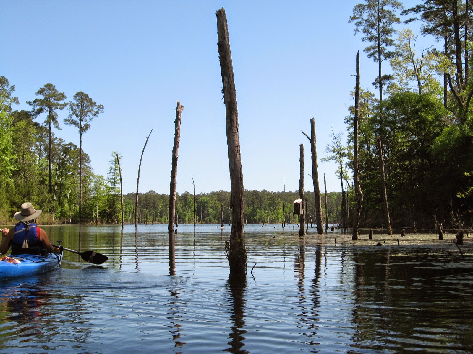
Mexican food. Sunday, we did a kayak on the lake the park is named after, and found a cool little inlet at the far end that we paddled a ways up.


In wet suits?


We were running out of time and headed back to fix Easter dinner, which was game hens on the grill with vegetable rice stuffing, and grilled vegetables. Got started late per usual, and didn't put enough charcoal in the pan, so I lost the coals before they were done. K also started late, so by the time we pulled everything and tried to eat, the veggies were still hard, and the hens only had parts here and there that were cooked. I gave it up and made a salad-K stuck it out and picked away at it. But the next night, after we'd moved to a forest service campground named Clear Springs, we threw it all in the oven, got it finished, and it was to was die for. As was the site we had in this CG-it had a deck that went right to the edge of a 30' drop, down into the little lake below, and was a great spot to just hang out at. Luckily it was, as we ended up here for 10 days, the last few because of weather. That was when northern Mississippi got hit with horrible tornadoes, and the storms producing them were passing us just to the north, within hearing and seeing distance.


The lake at Clear Springs below our site


Feel'in quite special at our lake view spot!


View from across the lake

We had a blast here-lots of stories (collective groan from everyone, no doubt!), but I'll try not to get too long winded, even though I already have. We did some drives, explored Meadville, just up the road, and Bude, just up the road from Meadville. In Bude, we got hailed on the sidewalk by an old fellow with a cane, who asked about the kayaks on the car, and ended up in a 10 minute conversation with him. He was drafted into the Army in 1950, and retired from it in 1987. I thought Vietnam would have been bad enough to experience, but that and Korea? I was in awe of him. We had to hit the hardware store, where another 10 minute conversation took place with the 2 woman working there, who told us of Lake Okhissa nearby, which we checked out before we went back to camp and decided we needed to throw the kayaks in there at some point. We then hit the tiny grocery store in Bude, Sullivan's, and what do we find? Cheap produce! After seeing red and yellow peppers running up to 3 to 4 bucks EACH all through the south, here they were a buck a piece! Same went for their meat prices. Chuck roast was running $4.99 to $6.99 everywhere up to this point-they had it for $3.99 a pound-bought one and cooked a “faux” brisket-whoa-hit the jackpot with THAT one! Jack Danial's BBQ sauce mixed with pureed chipotle and a little vinegar to cut the sweet and add some tang, then thick onion slices with the sauce on both sides in foil & on the grill it went.

The next day we had to deal with Gus, who was scratching her skin off, had a rash on her chest and was drinking water without let up. Took her to a vet in Meadville named Melanie Branston. What a pistol! Straight out of the old days and sharp as a tack, and tells it to you straight-she never heard of political correctness and it was refreshing! The place was a jumble of stacks of books, vet tools, x-ray machine, exam tables, huge birds in cages inside, even bigger birds in bigger cages outside, goats, dogs, cats-you name it. She spent two & a half hours going over Gus and Yoda, prescribed prednisone for Gus, and what to do with Yoda's hot spot, shaved the hot spot, gave us 30 days worth of the drug, set us up with an internet outfit for refills, and charged $90! That all would have been 5 times that in NH, if you could GET a vet to spend that much time. And she was a hoot just to talk to-talk about rough and tumble & full of stories-but I sure as hell wouldn't want to have her mad at me!

Towards the end of the week, we headed back to Bude to paddle Okhissa, but stopped for breakfast at the “First and Main Cafe” and almost didn't leave! You don't go anywhere in a small town in the deep south and get away with walking by someone-they somehow know your not from around there and stop you, by saying hello and asking how you are, and start asking questions. You will almost always wind up in a hilarious back and forth, and you cannot be in a hurry. You will go 5 feet and it will happen again, or a crowd gathers 'round and you meet the whole town (or at least half of it) right then and there. The south is the friendliest part of the country by far. Black, white or any other color-they are all friendly want want to know about you. And extremely funny! Everyone is introduced (or introduce themselves) and Ms. (first name) or Mr. (first name).

When we went in, there was one older fellow there (Mr. Leon, as it turned out) waiting for his food. Ms. Jenny was the proprietor, cook and dishwasher, and came out and greeted us while she brought Mr. Leon his breakfast. She was very good at doing all she had to do with a running commentary going full tilt at the same time! We ordered, and another, younger fellow named Don came in, and then it started! He kind of looked and sounded like a tall, Tommy Lee Jones-what a character, and we had a really fun time all getting to know each other. He orders his standard breakfast, a BLT, and starts firing questions, and a conversation started up that had everyone involved, and us in tears laughing at times. Don's retired, but has lots of hobbies he says, one of which was learning to run his I-phone, which he then pulls a chair up next to K and proceeds to show her what he can do with it. He even brought Mr. Leon into it, once Mr. Leon had finished eating. Mr Leon told of making a run to San Diego and back with his nephew recently, in 3 DAYS! I'm guessing he was around late 70's early 80's. By the time it was over, we had spent 2 & ½ hours in the cafe, including Don insisting we follow him to his girlfriends house down the street, because another of his hobbies is making jelly, and he wanted to give us some! A blueberry and a blackberry-so far, the blueberry is delicious!


Mr. Don, Miss Jenny and Mr. Leon


Ford dealer on main street Bude across from First and Main Cafe-looks like they ran out of cars. Looks like they ran out of roof too!


In Bude, everyone is so laid back!

The kayaking on Okhissa was beautiful, and I'll let the pics tell that story-great day overall!


On Friday of that week, the storms that caused so much damage in northern Mississippi started. We packed up, and stayed that way, in case we had to bolt. The CG host let us know that the church down the road was unlocked and open to anyone that needed shelter, as they had a basement, not very common down there. Fortunately, we didn't need to use their hospitality! Saturday, we had another funny adventure, in no small part due to my wife's expertise with nickel slot machines (they're the ones that squeak when the wheels turn, because the people playing them are so cheap). We went into Natchez for a blues festival on Saturday, that was being held in a park on a bluff overlooking the Mississippi. A group of 50 somethings was playing stuff that sounded more like a high school garage band-really, really bad! So, we decided to walk down the road that left the park and went down to the river. Low and behold, what was down there but a casino! It was early afternoon and hot-mid to high 80's, so we decided to hit the bar and have a beer. We also had a phone call to make at 2 o'clock, so time-wise it was perfect-or so we thought! We talked to the receptionist, who directed us to the bar. We ordered our beers, and tried to pay, but the bartender explained that they don't sell drinks-they are free for people playing in the casino. She also told us that if we were first timers at the place, we could each get a $10 complementary card to play the slots, which also would take care of of the beer issue. SO, what does Mrs. B do with 2, $10 complimentary cards? Proceeds to make numerous $2 to $4 wins, cashing out each one as she goes, for a total of $17 cash-in-hand, plus the 2 free beers!!! And if we hadn't had to make that 2 O'CLOCK PHONE CALL, Mr & Mrs LONGPANTS, we would have been able to spend more time with the free beer! You two owe us! :>) 

Some pics of Natchez and the Mississippi:


Looking north from the park on the bluff


Tow full of coal coming south


A local pooper scooper model


I WANT THAT TRUCK!!!!


Monday, May 19, 2014

Starting Up the Mississippi-Baton Rouge to Simmesport/Three Rivers RA


May 1, 2014-Greenville, Miss.-K-

All is well with us.  We have finally started our trip up the Mississippi, and this is the first days drive.  We are so excited to be starting something we have never done and something we have always wanted to do, which is to be following the spring north. It will be really interesting to watch the changes in foliage as we head north. For some reason, we set the map up on the route we actually took, and when we preview the embedded version, Google has changed it to what Google Maps thinks it should be when you paste it into the blog-frustrating! There's two large loops north of I-10 that we actually did follow, at times on the levee top, where the map shows us further west of the river.

We left Abbeville, LA on April 15th and headed east and north and in order to avoid Baton Rouge.  It wasn't too long when we came upon the Mississippi levee that we would follow all day.  Unfortunately the views of the river are nil because of that.  Mostly they are used for grazing cows and horses.  But the grass is lush.  There are huge fields of winter wheat that will be harvested around the end of May after which they will plant soybeans. The wheat adds nitrogen to the soil for the soybeans. Corn has just been planted and is about 3" high.


Cows grazing on the levee.

We really wanted to get up on the levees, but most of the access roads are posted, so it wasn't an option. However, we finally found a way to get over it and on the water for a short spell.


Watch that first step of the deck!


The water was a bit high from all the snows up north.


Yippee we made it to the river!!!


Winter wheat field on Bean Field Road, near Simmesport, LA


Ladybugs


Lone church and cemetery carved out of a soon to be planted field.


I hope so.

We ended our first day at Three Rivers Wildlife Management Area. VERY interesting area, mainly run by the Army Corps of Engineers. We had a free camp spot to ourselves for most of our stay. (We did get invaded by a cranky fisherman and his wife, but then, I'm cranky most of the time too, so we just sat and glared at each other-well, I sat-he leaned on the tailgate of his truck). The kayaking there would have been great, but for the wind, so we did some driving around and checking things out, as well as finishing the installation of a fourth solar panel on the roof. The road past the campground (Bean Field Road) continued on into the gigantic winter wheat field in the pics above-the wheat was almost above the car and was a beautiful spring green color. There was an ACOE worker that visited us every day, and we learned a lot from him about the whole Three Rivers system he worked in. It turns out that 3 rivers all almost come together there-The Mississippi, the Atchafalaya and the Red. This is where it got interesting-back in the 1800's, Captain Shreve, a riverboat captain and whom Shreveport is named after, decided to cut a channel to eliminate a long switchback in the Mississippi and make a straighter riverbed. Then, in the early 1900's, the ACOE built levees and lock systems all along the Mississippi, and the combination of the two started caused the Mississippi to start using the Atchafalaya drainage and begin to abandon it's existing course from there down through Baton Rouge and on to New Orleans. The ramifications of that change were enormous if it were allowed to continue, between the petroleum industry that had built up along the lower river that used it for water in manufacturing and for shipping, the major cities that relied on it for drinking water, and the huge amount of agriculture down here.

In the early 1950's they built most of what exists today-some channels to let the Red river into the Atchafalaya as it always did, and some other dams and channels to insure the Mississippi stays in it's existing bed, along with a lock for barge tows to move back and forth between the Atchafalaya/Red and the Mississippi. Later flooding, I believe in the 70's, cause them to construct more flow control dams beyond where we were staying, which we checked out on a drive, and again when we left, as they were on our route.
 Camp at Three Rivers. The lock (below) is on our left, about 1/4 mile away

Adding panel #4, which gives us about 25 amps of recharging power on sunny days & about 4 to 5 on the cloudy ones.  

The lock on the Atchafalaya side-they lower the tows down to the Mississippi, and bring the empty barges back through the same way.

A tow moving into the lock. 

Gottcha!

Sunday, May 4, 2014

4-7-14 A Ride Around the Block in Louisiana


Friends that know us well, know of our love of "rides around the block" and looking for "blank spots on the map", and going there to see just how blank the area really is! In Westcliffe, we have an around the block ride that's @ 20 to 25 miles, and takes 2 & 1/2 hours. We have taken our neighbor (whose name shall remain nameless to protect his privacy-that okay there "longpants"?) around on it twice, once while he drove, and he still can't do it solo!

On Monday, April 7th, we combined both approaches and took a drive over a road we had driven on when we came into Abbeville from Texas in 2010. Rt. 82 originates near  Port Arthur, Texas, which is where we left from in 2010 and headed east to Cameron, Louisiana and on to Abbeville. We always wanted to go back and explore the country along that lonely road, which we did on this drive. As the saying goes, "It's not the end of the world, but you can see it from there"!

That southwest corner of Louisiana, an area about 100 miles long and 50 miles deep, is all marshland-there is no shore, and no beaches. It's also full of lakes, both large and small, and is a lot like a map of northern Canada, with few roads and lots of lonely country. People do live there, in the few places high enough to be out of the water, but recent hurricanes in the last 10 years have destroyed a lot of property, and many people have left, not bothering to rebuild. Quite a few places are/were weekend getaways and hunting/fishing camps. Other than the 2 state highways that traverse it (82 and 27), every side road dead ends, either at a pier, an oil installation or at a locked gate. There are also a bunch of wildlife refuges-some accessible by car, but most only accessible by boat. We poked around 2 of them, Rockefeller State Wildlife Refuge and Cameron Prairie NWR.

The road out of the campground (Palmetto Island State Park) ends at Rt 82, so from there to Forked Island you are still in farmland, but at that town you cross the intracoastal waterway on a very tall bridge, and down on the other side, the marsh begins and you are surrounded by marsh grass off and on for the next 60 miles.


We had spotted a road on Google Maps, Freshwater City Road, that left Rt. 82 at Pecan Island, and headed south down to the Gulf, so we did too. What a crazy drive! It was about 12 miles long, and continued on in even taller marsh grass. The pavement soon quit and we were on gravel. Don't ask me where they got it-there is none in southern LA, and no rocks you could crush to make it with either. After a bit, we came to some houses, one of which was a really funky house that had a pair of rowboat planters out front. The place was manicured to  "T", something you just don't see in these parts, and whoever was living in it was doing a beautiful job. We didn't get the greatest pictures here, as it's a little weird to be standing out on a road taking pics of someone's house. Especially in southern Louisiana-it could be detrimental to one's lead-free health.


Across and down the road from that place was...grazing CATTLE! And the pavement also restarted, after a 5 mile hiatus. 


This road did not have any curves-every turn was a right angle change in direction, and when we whipped around a corner on one of them, we got a little surprise...we weren't sure who had the right of way, but at least the boat was in the proper lane.


A couple more turns & we saw what was going on-shrimpers, and that we were at the end of the road. The picnic bench is a tiny Fish and Wildlife picnicking & fishing area. Nearby were docks for oil service companies as well as the fishermen, all on a channel that took them into the Gulf of Mexico.


The fellow in the blue coat out at the end was fishing, and hobbled all the way over to us to ask for a light-we didn't have a thing with us to light a smoke-we felt bad, as he struggled so to walk. We also have NO idea how he got there, as there was no car, and there were no houses for miles. His "tackle box" was a plastic grocery bag.

All in all, it was a great side trip-here's some other sights we saw along the way:


Glad they replaced the bridge!!!


We continued west when we got to Rt. 82, stopping somewhere alongside it to eat the lunch we brought along. There's not much of anything but marshland on the 30 miles between Freshwater City Road and the Rockefeller National Wildlife Refuge's west end, where the only road into the Refuge (Price Lake Road), heads south for 3 miles before dead-ending at a dock and an observation tower. 


We took a few pics there, but discovered the first flight of stairs was missing off the observation tower! You could get on it if you were nimble enough to jump up and grab the last stair tread and pull yourself up, but those days are long over for me! I asked K to do her wifely duty and let me stand on her shoulders, but she just laughed and tried to push me off the dock and into the alligator infested waters. Cheesh-I've lost enough hair without one of them chewing the rest off! Somehow, we forgot to get a pic of the tower on top of it all, but here's a Heron fishing off the dock. Big "L's" on our foreheads!


Another 32 miles took us through Grand Chenier, one of the towns struggling to survive, with less and less structures remaining after each hurricane that comes through, and into Cameron. Along the way, we tried to take Earl Road, which, had we been successful, ran deep into the marshlands to the north, and by a couple of remote Refuges, and wound back down into the back side of Cameron. Alas, we started up Earl Road, waved at the two old guys sitting on their front porch, went 2 miles north, around a 90 degree left and ran smack into a locked, steel gate. HATE it when that happens! We got turned around and retreated back to Rt.82, waved at the two guys again, and headed west into Cameron. Which we ALSO neglected to take any pictures of!  So, here instead are some pics from 2010, coming east on Rt. 82 from Texas. Rt 82 starts and ends at Cameron, and to continue on it or get to Cameron from Texas, you have to board a free ferry across the outlet of Calcasieu Lake.


Approaching the bridge over Sabine Pass, which is the Texas-Louisiana border, from the Texas side.


View off the top of the bridge, looking south at a jacked up oil rig under repair. We had taken a drive down through there a few days before and the thing was huge. 


We also visited a non-existent Texas State Park on that same drive, that was literally blown away in a hurricane, leaving only a few stretches of asphalt, and that was it. All  the buildings were gone.


Along Rt. 82 heading to the Cameron ferry through Johnsons Bayou and Holly Beach.


Along Rt. 82 heading to the Cameron ferry


End of the road, and waiting for the boat.


Random ferry passenger from that red car next to me.


 Another random ferry passenger!


No idea what this boat was for, but it sure was impressive! And I used to think the hose reels on the airports fuel trucks were big!


A local fix-it guy....couldn't cure my hair loss though.

So from Cameron now (in 2014) we back-tracked on Rt. 82 to to Rt. 27, and headed north towards Lake Charles. The last stop was along this road out of the great marsh, at Cameron Prairie NWF. Lots to see here, with a 1/2 mile boardwalk through a section of open swamp, and a drive around a bigger section of the Refuge, with a lot of alligators around.


Couple of boardwalk pics above


You gotta wonder who's crazy enough to try and take a bite out of an alligator, much less two! So THIS what they mean by "gator bites" on the restaurant menus...


Hunting from his man blind. I wonder if he has a Labrador Retriever to bring the bodies back to him....

From there we scooted along up to Rt 14 and followed it east back to Abbeville, a spectacular 235 mile ride around the block. Would love to get hold of a boat and see some of the interior some day.